|
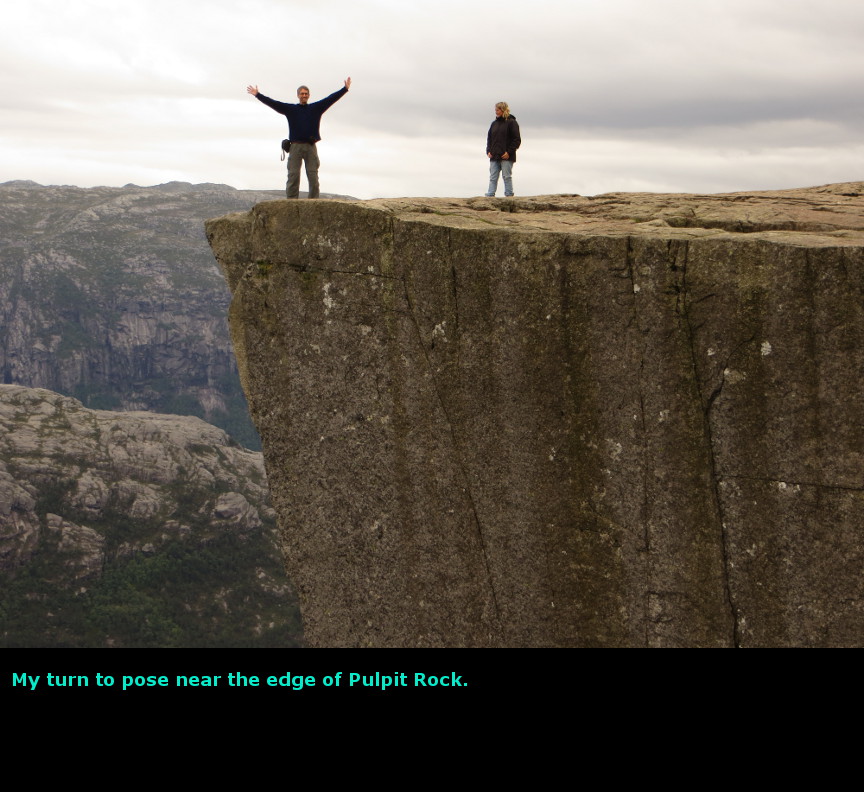
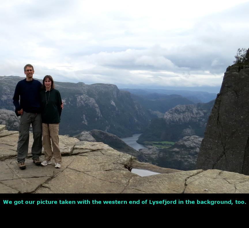
The highlight of this day was the hike to the amazing Pulpit Rock. When I planned for our visit to Norway, two things were clear. First, Pulpit Rock is an iconic site Norway, it is a must-see highlight destination for everyone visiting the country. Second, getting to Pulpit Rock would be difficult, because it was much further south than all of the other places on our list. Since I did not want to skip Pulpit Rock, I put in a long day of driving all the way south from Bergen. According to the mapping websites, you could drive from Bergen to Pulpit Rock in little more than six hours, plus time waiting for ferrys. We could have gone straight south from Bergen to Stavanger before crossing over to Pulpit Rock, but that required three long (and possibly expensive) ferry crossings. Instead, I picked a route that had only two short ferry crossings. As a bonus, we got to see our first Norwegian waterfalls along the way. We ate another huge breakfast at the Bergen Montana Hostel, and then we were on the road early. We had our route planned out - see the map below. We saw three waterfalls before we reached the first ferry, each waterfall was more impressive than the previous one. The last fall was Steindalsfossen, which had a parking lot and a trail right up to it. The trail allows you to walk behind the waterfall, but we were in a hurry to get all the way down to Pulpit Rock, so we did not do the walk behind Steindalsfossen. Our first ferry ride was the Třrvikbygd - Jondal crossing. We learned that the fee for a ferry depends on the number of passengers in the car, and on the size of the vehicle. Since our old-fashion American credit card does not contain a security chip with a PIN number, we had to pay cash on all ferry crossings. After the ferry, we drove through a couple of long tunnels, both of them over 10 km in length. These tunnels were recently constructed; they go all the way under the Folgefonna National Park and its ice pack. South of Odda, we stopped at a popular viewpoint for the twin torrents of the Lĺtefossen falls. Two powerful waterfalls spill down right next to the roadway - the road passes in front of them on an arched stone bridge - so it is a scenic view. The spray from the falls means you have to keep wiping the lens of your camera when trying to get a shot. We drove south from there. It was slow going in some stretches. South of Horda, Route 13 becomes a single lane road that winds alongside some long lakes. There are many tunnels. The scenery is nice, but it isn't spectacular. Driving along here made me realize how difficult it must have been for early Norwegians to get around. There are steep mountain cliffs and deep lakes and fjords blocking every route. Without the benefits of tunnels and ferries it would be a multiday expedition just to get over to the next valley. After we finally reached the Nesvik-Hjelmeland ferry, we were getting close to Pulpit Rock. But then it started to rain. I was discouraged by this, because I really wanted to see Pulpit Rock, and I wanted to admire the famous view without clouds obstructing the vistas. The rain picked up, and then it eased off, until it stopped entirely about the time we reached Jřrpeland. Jřrpeland is the town closest to Pulpit Rock, we had a reservation at the Verkshotellet hotel for that evening. It was almost 4 P.M. when we reached Jřrpeland, but I knew that we would still have plenty of daylight for our Pulpit Rock hike - I had checked earlier to see that the sun set at 9:22 PM on August 16th in Stavanger (which is right across the water from Jřrpeland). We found a place called Pizzabakeren, and ordered a quick ham and mushroom pizza. We wanted to eat early, because it would be quite late when we finished Pulpit Rock - the average round trip time is 4 to 5 hours, including time spent at the top. The trailhead for Pulpit Rock (called Preikestolen in Norwegian) is just 9 km from Jřrpeland. There is a huge parking lot there, which costs NOK 100 to park there. Apparently the parking lot, large as it is, overflows on summer days, because there is a second parking lot about a kilometer further back down the hill. I was glad we were able to use the primary lot, it looked like a steep hike to get from the secondary lot up to the trail. The hike itself is not too hard. It is only 3 km one way, though there is some climbing, especially at the beginning. The trail is in good shape and it is quite wide. After the first kilometer, it started to rain again, which really was disappointing to me. We put on our rain gear and used the umbrella and continued hiking. After only about half a kilometer, the rain stopped completely, so we were rewarded for continuing onward. Before too long we reached Pulpit Rock! Pulpit Rock is a dizzying height above Lysefjord - the water is about 600 meters (1950') below the rock. It is scary to look down, but it is also exhilirating. The rain clouds were up high, so we had wonderful views both up and down the fjord. It was thrilling to be up on the rock and see the fjord stretching off in both directions. We tried to get pictures facing to the west and the east, looking up and down Lysefjord. There is a large crack in the Pulpit Rock, running parallel to the cliff face. So eventually, Pulpit Rock will sheer off from the edge and plummet into the waters below, but that could be centuries from now. The view from the rock stretches for miles. I got down on my hand and knees and crawled to the edge at a couple of points, just to peer down to the immense drop below. It is not a place for people with a fear of heights! Behind Pulpit Rock there are some cliffs that people scramble up - we went part way up to see if it would give us a dramatically better view. But I think you need to climb all the way to the top to really look down at Pulpit Rock, and we did not go that far. We began our hike up Pulpit Rock at 4:45 P.M., and finished at 8:15 P.M. We still saw a few people walking up as we were headed down. I suppose on a day with clear skies, you might sit on the rock and watch the sunset, and then hike down in the twilight. In retrospec, our hike to Pulpit Rock couldn't have been better timed. Because we started so late in the afternoon, we missed a lot of the crowds. Even though it had been a rainy day, we passed many people coming down when we were hiking up. We overheard one guy commenting about how people had to queue up to get up the trail just to reach Pulpit Rock. The trail is wide in most places, but a large wave of humanity can overwhelm any trail. The top of Pulpit Rock is not as big as I expected, it looked larger in the photographs. If there had been busloads of people up there, it would have led to a lot of jostling to try and get good views and nice photographs. I think the short bursts of rain also discourage potential hikers. The next day, when waiting for a ferry, I talked to a guy from Germany. He told me that he wanted to hike Pulpit Rock in the afternoon (which was when we did our hike), but he had been deterred by the weather. So in the end we got to enjoy this popular attraction, and see the marvelous views, without too much crowding. However, to exit the parking lot requires you to pay NOK 100, and they do not have a human attendant at the gate in the evening. Since our credit card doesn't work in automated machines in Norway, we had to find someone that could exchange a NOK 100 bill (which the machine does not take) for NOK 100 in coins (the parking machine does accept coins.) We checked into the Verkshotellet back in Jřrpeland. It seemed like a new hotel, or at least it was newly remodeled. The room wasn't big, but it was nice and clean, with a helpful staff. I couldn't figure out how to turn on the lights - it turns out that you have to insert the room key into the switch to enable the lights. I am not sure what the point of this feature is - perhaps to ensure that you turn off the lights when you leave the room with your key? Although this was a long driving day, it turned out to be quite a success. We saw the highlight site of Pulpit Rock in good conditions, plus we successfully made our first navigation of all the tunnels and ferries of Norways road system. Today we drove 350 kilometers. Panorama Photos

MapsHere is the route we drove from Bergen all the way down to Pulpit Rock 
This is a contour map of the hike to Pulpit Rock 
To display the photo images on this webpage, I am using a freely distributed java script called Lightbox v2.7.1 written by Lokesh Dhakar. You can download this program by clicking on this link. All the text and photographs on this webpage are my own creation, but the textured background is taken from a site, EOS development, that offers non-profit users free use of their graphics. Click the icon below to visit their site.
|
Click on any thumbnail to begin the slide show at that photograph Pulpit Rock Photos


|